
Tour Gourmand
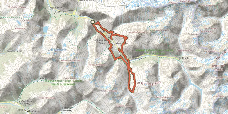
Key facts
- Distance
- 39.0 km
- Ascent
- +3,378 m
- Descent
- −3,302 m
- Estimated time
- 18 hr 30
- hiking
- Difficulty
- Moderate
- official rating
- Route
- Point to point
- ends elsewhere
Profile and gradient
- under 10%
- 10 to 20%
- over 20%
Gradient along the route: 14.0 km under 10%, 10.5 km at 10 to 20% and 14.5 km over 20%. Elevation from 1,169 m to 2,561 m over 39.0 km.
Surface and path types
- Surface
- Paved 2%
- Dirt & gravel 97%
- Unknown 1%
- Path types
- Trail 96%
- Track 1%
- Road 2%
- Off-network 1%
Description
After each day spent immersed in nature, the Tour Gourmand invites you to discover the gastronomy of the mountains over 5 stages. The Gourmet Tour includes a mountainside hike around Saint-Christophe-en-Oisans between the mountain pastures, the secret valleys and some breathtaking panoramas. Each day, everywhere you stay, you enjoy a new culinary speciality. You set off beside the River Vénéon in a valley environment, before soon heading up to spend the night in the mountain pastures in the attractive Alpe du Pin refuge with its local organic cuisine. In the mountain pastures, the trail starts off flat around the mountainside before heading down through a beautiful forest as far as the neighbouring valley of the Lavey, with glaciers, mountain peaks, a welcoming refuge and delicious world cuisine. After a refreshing night, the walk up towards Les Fétoules Lake unveils a superb panorama. Then you go down into the valley before arriving on the south-facing slope, with its lobed-leaved trees and the great mountain cooking at Les Arias gîte. The next day is a long one, calling for plenty of energy, as it takes place on the Plat de la Selle, the highest point of the week, at an altitude of 2,550 m and an unmatched panorama over the Vénéon valley. A mountainous passage leads down to the heights of St-Christophe with its hotels, where you can enjoy some creusets, the speciality of the village. This is a perfect starting point for the last day, which is a relatively easy one, with its attractive path winding its way around the mountainside, between the former farming terraces in the village of Le Puy. One last, fairly steep descent takes us down to the Plan du Lac, the trail's starting and finishing point.
Difficulty
Official rating: moderate, by Parc national des Écrins.
Before you go
- Early in the season, you should ask about snow levels on the trail. Several passages maybe filled with frozen snow. The refuges are open from about mid-June to mid-September. Early in the season, you should ask about snow levels on the trail. Several passages maybe filled with frozen snow. The refuges are open from about mid-June to mid-September. Don't forget to book !
Getting there
Start: Parking à côté du barrage, Les Deux Alpes (38).
Sources
- Track: Parc national des Écrins, Licence Ouverte 2.0, Licence Ouverte 2.0 (Etalab) (destination.ecrins-parcnational.fr/trek/950834-Tour-Gourmand). Time estimated by GPX Path with the Mac app rule, breaks not included.
- Surface and path types: © OpenStreetMap contributors, ODbL, extract of 28 October 2026, matched to the track every 10 m (openstreetmap.org/copyright)
- Official elevation gain: 3,378 m, Parc national des Écrins
Nearby tracks

 Plan IGN © IGN 2026Le vallon de LanchâtraÉcrins, Saint-Christophe-en-Oisans (38) · Out and backOfficial rating by Parc national des Écrins
 Plan IGN © IGN 2026Muzelle LakeÉcrins, Les Deux Alpes (38) · Out and backOfficial rating by Parc national des Écrins
 Plan IGN © IGN 2026Tour de l'Aiguille de VénoscÉcrins, Les Deux Alpes (38) · Point to pointOfficial rating by Parc national des Écrins
 Plan IGN © IGN 2026Le refuge de la SelleÉcrins, Saint-Christophe-en-Oisans (38) · Out and backOfficial rating by Parc national des Écrins
 Plan IGN © IGN 2026Travers des lacs par l'Alpe du PinÉcrins, Saint-Christophe-en-Oisans (38) · LoopOfficial rating by Parc national des Écrins
 Plan IGN © IGN 2026Plan Vianney lake and the Périer gapÉcrins, Les Deux Alpes (38) · Out and backOfficial rating by Parc national des Écrins