
Muzelle Lake
Key facts
- Distance
- 11.7 km
- Ascent
- +1,261 m
- Descent
- −1,253 m
- Estimated time
- 6 hr 40
- hiking
- Difficulty
- Difficult
- official rating
- Route
- Out and back
- same way back
Profile and gradient
- under 10%
- 10 to 20%
- over 20%
Gradient along the route: 1.8 km under 10%, 4.1 km at 10 to 20% and 5.9 km over 20%. Elevation from 935 m to 2,146 m over 11.7 km.
Surface and path types
- Surface
- Paved 6%
- Dirt & gravel 89%
- Unknown 5%
- Path types
- Trail 89%
- Road 6%
- Off-network 5%
Description
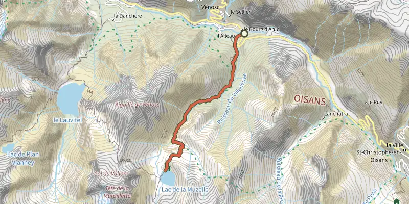
This hike goes through a forest of resinous trees and Beech trees until the refuge and the lake at Muzelle... Going up to Muzelle lake is like touching the past. Go up to the waterfalls following the traces of the shepherds... Discover, the ultimate reward, the lake where the imposing suspended glacier is reflected... The comfort of the refuge, pastoral calm, magical moments... André Brun, retired park ranger in the sector of Muzelle. From the car park which is next to the left bank of the Vénéon just after the bridge, take the narrow road that leads to the end of Alleau hamlet. Go over the little bridge and take the paved path that goes up steeply into the forest. . After a few bends, a long restful crossing enables you to reach "le Cerisier", a group of houses in ruin. Continue on the path which follows the left bank of the Muzelle torrent, these bends lead to waterfalls which are very welcome in times of great heat. When you arrive at the foot of a big shale slope, the track zig-zags across the torrent and there are many bends to reach a beautiful lawn, then a basin full of bog. Arrive finally at a little hill to see the Muzelle lake and its refuge. Go down on the same path.
Difficulty
Official rating: difficult, by Parc national des Écrins.
Getting there
Start: L'Alleau, Vénosc, Les Deux Alpes (38).
Sources
- Track: Parc national des Écrins, Licence Ouverte 2.0, Licence Ouverte 2.0 (Etalab) (destination.ecrins-parcnational.fr/trek/903460-Le-lac-de-la-Muzelle). Time estimated by GPX Path with the Mac app rule, breaks not included.
- Surface and path types: © OpenStreetMap contributors, ODbL, extract of 28 October 2026, matched to the track every 10 m (openstreetmap.org/copyright)
- Official elevation gain: 1,261 m, Parc national des Écrins
Nearby tracks

 Plan IGN © IGN 2026Tour de l'Aiguille de VénoscÉcrins, Les Deux Alpes (38) · Point to pointOfficial rating by Parc national des Écrins
 Plan IGN © IGN 2026Tour GourmandÉcrins, Les Deux Alpes (38) · Point to pointOfficial rating by Parc national des Écrins
 Plan IGN © IGN 2026Le vallon de LanchâtraÉcrins, Saint-Christophe-en-Oisans (38) · Out and backOfficial rating by Parc national des Écrins
 Plan IGN © IGN 2026Plan Vianney lake and the Périer gapÉcrins, Les Deux Alpes (38) · Out and backOfficial rating by Parc national des Écrins
 Plan IGN © IGN 2026Lauvitel LakeÉcrins, Les Deux Alpes (38) · LoopOfficial rating by Parc national des Écrins
 Plan IGN © IGN 2026Le refuge de la SelleÉcrins, Saint-Christophe-en-Oisans (38) · Out and backOfficial rating by Parc national des Écrins