
Béal des Abrits

Key facts
- Distance
- 4.7 km
- Ascent
- +218 m
- Descent
- −169 m
- Estimated time
- 1 hr 25
- hiking
- Difficulty
- Moderate
- official rating
- Route
- Loop
- back to the start
Profile and gradient
- under 10%
- 10 to 20%
- over 20%
Gradient along the route: 3.2 km under 10%, 1.4 km at 10 to 20% and 0.1 km over 20%. Elevation from 383 m to 535 m over 4.7 km.
Description
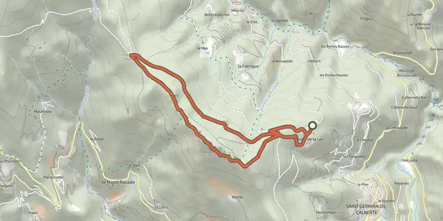
Here is extraordinary evidence of human stubbornness in channelling water according to need, from a time when technical equipment was very basic. From the parking spot, walk on the road for 600 m towards the hamlet of Les Abrits, then take the path on the left and go downhill under the chestnut trees. 1) At the abandoned mas (isolated farm), walk below the ruins and follow the path. 2) Cross the small stream and, before you arrive at the second stream, leave the path and take on the right a path that goes downhill towards the Gardon de St Martin river. Walk to the Gardon. 3) Do not cross the Gardon: the path follows the béal (irrigation channel) on the right. Careful: the rocks are slippery when wet! 4) At the end of the béal, walk to the gourgue (mill pond) and climb the path to the road. At the road, turn right and continue back to the parking spot.
Difficulty
Official rating: moderate, by Parc national des Cévennes.
Before you go
- Careful: The path alongside the Gardon river is very slippery when wet. Make sure your equipment is appropriate for the day’s weather conditions. Remember that the weather changes quickly in the mountains. Take enough water, wear sturdy shoes and put on a hat. Please close all gates and barriers behind you.
Getting there
Start: Sur la route d'accès au hameau des Abrits, Saint-Martin-de-Lansuscle (48).
Sources
- Track: Parc national des Cévennes, Licence Ouverte 1.0, Licence Ouverte 1.0 (Etalab) (destination.cevennes-parcnational.fr/trek/43861-Beal-des-abrits). Time estimated by GPX Path with the Mac app rule, breaks not included.
- Official elevation gain: 218 m, Parc national des Cévennes
Nearby tracks

 Plan IGN © IGN 2026CastelvielCévennes, Saint-Martin-de-Lansuscle (48) · LoopOfficial rating by Parc national des Cévennes
 Plan IGN © IGN 2026The Rocks of GaltaCévennes, Saint-Germain-de-Calberte (48) · LoopOfficial rating by Parc national des Cévennes
 Plan IGN © IGN 2026Trail of MemoriesCévennes, Sainte-Croix-Vallée-Française (48) · LoopOfficial rating by Parc national des Cévennes
 Plan IGN © IGN 2026La FlandonenqueCévennes, Saint-Germain-de-Calberte (48) · LoopOfficial rating by Parc national des Cévennes
 Plan IGN © IGN 2026Saint-Germain-de-CalberteCévennes, Saint-Germain-de-Calberte (48) · LoopOfficial rating by Parc national des Cévennes
 Plan IGN © IGN 2026Grisou the MuleCévennes, Saint-André-de-Lancize (48) · LoopOfficial rating by Parc national des Cévennes