
THEMED PATH: The Serre-Duc Canal
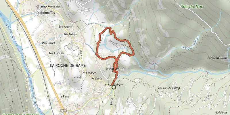
Key facts
- Distance
- 2.4 km
- Ascent
- +139 m
- Descent
- −131 m
- Estimated time
- 50 min
- hiking
- Difficulty
- Easy
- official rating
- Route
- Loop
- back to the start
Profile and gradient
- under 10%
- 10 to 20%
- over 20%
Gradient along the route: 0.9 km under 10%, 1.3 km at 10 to 20% and 0.2 km over 20%. Elevation from 1,013 m to 1,124 m over 2.4 km.
Surface and path types
- Surface
- Paved 39%
- Dirt & gravel 55%
- Unknown 6%
- Path types
- Trail 46%
- Track 9%
- Road 39%
- Off-network 6%
Description
A combination of water and tradition in the hamlet of Le Bathéoud... Points of interest along the route: Roam the lanes of Le Bathéoud to discover life in bygone times! Discover the path of the Serre-Duc canal, the old irrigation canals; all features that highlight the importance of water management in the hot, sunny municipality of La Roche-de-Rame! Start the walk by heading towards the bridge over the Bouchouse mountain stream. Facing away from the bridge, take the road opposite. - Turn right, and skirt around the right-hand side of the house. - Head right and, after a short rise, continue until you come to the irrigation canals. - Turn left to continue the walk. - You reach the hamlet of Le Bathéoud by turning left. - At the intersection with the path, turn left. Then, at the intersection with the road, continue left. - Skirt around the right-hand side of the houses and then back to the starting point of the trail.
Difficulty
Official rating: easy, by Parc national des Écrins.
Before you go
- Information panels are installed all along the path.
- The app “Les écrins sentiers thématiques” provides information about the trail.
- Check weather conditions before setting off.
- Rescue services contact details: Secours Montagne (Mountain Rescue): +33 (0)4 92 22 22 22 or 112
- Show consideration for the work of farmers, livestock keepers and owners
- Close all gates behind you
- Take your litter home
- Do not take shortcuts across pastureland
Getting there
Start: Le Bathéoud, La Roche-de-Rame, La Roche-de-Rame (05).
Sources
- Track: Parc national des Écrins, Licence Ouverte 2.0, Licence Ouverte 2.0 (Etalab) (destination.ecrins-parcnational.fr/trek/960143-SENTIER-THEMATIQUE-%3A-Le-Canal-de-Serre-Duc). Time estimated by GPX Path with the Mac app rule, breaks not included.
- Surface and path types: © OpenStreetMap contributors, ODbL, extract of 28 October 2026, matched to the track every 10 m (openstreetmap.org/copyright)
- Official elevation gain: 139 m, Parc national des Écrins
Nearby tracks

 Plan IGN © IGN 2026RANDOLAND : La Roche de RameProvence-Alpes-Côte d'Azur, La Roche-de-Rame (05) · LoopOfficial rating by Parc national des Écrins
 Plan IGN © IGN 2026THEMED PATH: The precipice pathÉcrins, Champcella (05) · LoopOfficial rating by Parc national des Écrins
 Plan IGN © IGN 2026Ascension Lake LoopProvence-Alpes-Côte d'Azur, La Roche-de-Rame (05) · LoopOfficial rating by Parc national des Écrins
 Plan IGN © IGN 2026Le sentier de ChampausselProvence-Alpes-Côte d'Azur, La Roche-de-Rame (05) · LoopOfficial rating by Parc national des Écrins
 Plan IGN © IGN 2026RANDOLAND : ChampcellaÉcrins, Champcella (05) · LoopOfficial rating by Parc national des Écrins
 Plan IGN © IGN 2026Le circuit de Clot LaffontÉcrins, Champcella (05) · LoopOfficial rating by Parc national des Écrins