
Circuit du Grand Jumeau
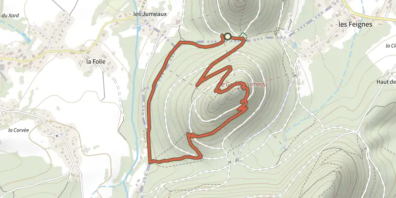
Key facts
- Distance
- 3.7 km
- Ascent
- +152 m
- Descent
- −164 m
- Estimated time
- 1 hr 10
- hiking
- Difficulty
- Not rated
- Route
- Loop
- back to the start
Profile and gradient
- under 10%
- 10 to 20%
- over 20%
Gradient along the route: 2.2 km under 10%, 1.3 km at 10 to 20% and 0.2 km over 20%. Elevation from 391 m to 551 m over 3.7 km.
Surface and path types
- Surface
- Paved 5%
- Dirt & gravel 95%
- Path types
- Trail 75%
- Track 20%
- Road 5%
Difficulty
No official rating for this track: we do not make one up.
Getting there
Start: Le Grand Jumeau, Nompatelize (88).
Sources
- Track: © OpenStreetMap contributors, ODbL 1.0 (www.openstreetmap.org/relation/10332569). Time estimated by GPX Path with the Mac app rule, breaks not included.
- Surface and path types: © OpenStreetMap contributors, ODbL, extract of 28 October 2026, matched to the track every 10 m (openstreetmap.org/copyright)
Nearby tracks

 Plan IGN © IGN 2026 · track © OpenStreetMapCircuit de la Cense de Saint-DiéVosges, Bois-de-Champ (88) · Loop
 Plan IGN © IGN 2026 · track © OpenStreetMapTour du KembergVosges, Taintrux (88) · Loop
 Plan IGN © IGN 2026 · track © OpenStreetMapCircuit des 3 fontainesVosges, Saint-Dié-des-Vosges (88) · Loop
 Plan IGN © IGN 2026 · track © OpenStreetMapPromenade Circulaire des CalvairesVosges, Mortagne (88) · Loop
 Plan IGN © IGN 2026 · track © OpenStreetMapCircuit de la Haute PierreVosges, Moyenmoutier (88) · Loop
 Plan IGN © IGN 2026 · track © OpenStreetMapCircuit de la croix Saint-GeorgesVosges, Saulcy-sur-Meurthe (88) · Loop