
The balconies of Saint-Marcellin
Key facts
- Distance
- 10.5 km
- Ascent
- +371 m
- Descent
- −349 m
- Estimated time
- 1 hr 05
- gravel
- Difficulty
- Easy
- official rating
- Route
- Loop
- back to the start
Profile and gradient
- under 10%
- 10 to 20%
- over 20%
Gradient along the route: 8.9 km under 10% and 1.6 km at 10 to 20%. Elevation from 970 m to 1,285 m over 10.5 km.
Description
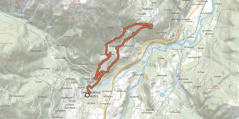
This itinerary takes you on a journey of discovery through scattered hamlets on the mountainside and beautiful Romanesque churches, while enjoying a panoramic view over the Durance valley! This route requires a little physical effort on the first ascent. But the reward will be great, with a panoramic view of the Embrunais mountains and the foothills of the Ecrins massif. The route takes you along narrow roads overlooking the Durance valley. Your camera will be busy! For your information: after Serre Buzard, there is an 800 m descent on a stony track. Stay focused or tackle this section on foot. - From the centre of the village, head north and pass over a stream. Continue on the D994h (Route d'Italie) then climb left towards Saint-Marcellin. Follow the "Coins du Monde" sign through the village. - The ascent is gradual and becomes gentler as you approach the hamlet of Serre Buzard. Stay on the main road, which narrows as it runs alongside the houses and reaches a cross at a fork in the road. - Now take a small track that descends to the right. The surface is not always smooth, so walk carefully down this section. Reach the Béguê fairly quickly, where the tarmac is more pleasant to ride on. - Cross the hamlet of La Touisse and glide down to Fontfourane. - Continue to Route d'Italie then return to Châteauroux-les-Alpes.
Difficulty
Official rating: easy, by Parc national des Écrins.
Getting there
Start: Parking centre-ville, Châteauroux-les-Alpes, Châteauroux-les-Alpes (05).
Sources
- Track: Parc national des Écrins, Licence Ouverte 2.0, Licence Ouverte 2.0 (Etalab) (destination.ecrins-parcnational.fr/trek/996005-Les-balcons-de-Saint-Marcellin). Time estimated by GPX Path with the Mac app rule, breaks not included.
- Official elevation gain: 371 m, Parc national des Écrins
Nearby tracks

 Plan IGN © IGN 2026Loop 54 - Les PinéesÉcrins, Châteauroux-les-Alpes (05) · LoopOfficial rating by Parc national des Écrins
 Plan IGN © IGN 2026Loop 53 - Les FontainiersÉcrins, Châteauroux-les-Alpes (05) · LoopOfficial rating by Parc national des Écrins
 Plan IGN © IGN 2026Around Lake Serre-Ponçon - GravelÉcrins, Embrun (05) · Point to pointOfficial rating by Parc national des Écrins
 Plan IGN © IGN 2026Loop 61 - Le BoscodonÉcrins, Embrun (05) · LoopOfficial rating by Parc national des Écrins
 Plan IGN © IGN 2026The banks of Serre-PonçonÉcrins, Embrun (05) · LoopOfficial rating by Parc national des Écrins
 Plan IGN © IGN 2026Loop 52 - The Balconies of Mont GuillaumeÉcrins, Embrun (05) · LoopOfficial rating by Parc national des Écrins