
Les Choulières circuit (no. 3)
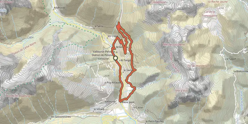
Key facts
- Distance
- 13.3 km
- Ascent
- +522 m
- Descent
- −493 m
- Estimated time
- 1 hr 55
- mtb
- Difficulty
- Moderate
- official rating
- Route
- Loop
- back to the start
Profile and gradient
- under 10%
- 10 to 20%
- over 20%
Gradient along the route: 11.0 km under 10% and 2.3 km at 10 to 20%. Elevation from 1,164 m to 1,586 m over 13.3 km.
Surface and path types
- Surface
- Paved 42%
- Dirt & gravel 58%
- Path types
- Trail 13%
- Track 48%
- Road 39%
Description
A lovely, tranquil circuit on the south-facing side of the municipality of Vallouise-Pelvoux This path - relatively easy but with a few technical sections - takes you through the south-facing side of the municipality of Vallouise-Pelvoux and will reward you with a fine panoramic vista over the valley. So you will have the opportunity to take in views of Mont Pelvoux and other legendary peaks in the area. The trail starts at the Pelvoux-Vallouise resort, near the Village Igloo - Cross the footbridge over the Gyr and head left onto the local road. Leave the road 200 metres further on, turning right towards the Domaine des Claux - At the end of the track, turn left onto the road leading towards Les Choulières - On the hairpin, go straight ahead along a narrow path heading towards the "Adret" (south-facing slopes). ⚠ Caution, dangerous section; if necessary, for safety's sake keep to the biking side along certain stretches - At the intersection, turn left towards Le Sarret - On the descent to the mountain stream La Juliane, continue straight ahead to cross it - At Belle Vue, turn left towards Le Poët and Vallouise - At the end of the track, head left, then right and then left again to take a narrow path taking you across the Paulin mountain stream (⚠ Be careful not to be caught by the current!) - Head left on a track which runs downhill to a paved road, then the local road in Vallouise - At the crossroads near the bridge, turn right to take a track, called Le Moulin, which runs along the left-hand bank of the Gyr - Cross the bridge spanning the Gyr and head right towards your starting point.
Difficulty
Official rating: moderate, by Parc national des Écrins.
Before you go
- Rescue services contact details: Secours Montagne(Mountain Rescue): +33 (0)4 92 22 22 22 or 112
- Show consideration for the work of farmers, livestock keepers and owners
- Take your litter home
- Do not take shortcuts across pastureland
Getting there
Start: Station de Pelvoux-Vallouise, Pelvoux, Vallouise-Pelvoux (05).
Sources
- Track: Parc national des Écrins, Licence Ouverte 2.0, Licence Ouverte 2.0 (Etalab) (destination.ecrins-parcnational.fr/trek/966626-VTT-N03---Circuit-des-Choulieres). Time estimated by GPX Path with the Mac app rule, breaks not included.
- Surface and path types: © OpenStreetMap contributors, ODbL, extract of 28 October 2026, matched to the track every 10 m (openstreetmap.org/copyright)
- Official elevation gain: 522 m, Parc national des Écrins
Nearby tracks

 Plan IGN © IGN 2026Les Claux circuit (no. 4)Écrins, Vallouise-Pelvoux (05) · LoopOfficial rating by Parc national des Écrins
 Plan IGN © IGN 2026The Onde circuit (no. 5)Écrins, Vallouise-Pelvoux (05) · LoopOfficial rating by Parc national des Écrins
 Plan IGN © IGN 2026The Puy Saint-Vincent green route ("Voie Verte")Écrins, Puy-Saint-Vincent (05) · Out and backOfficial rating by Parc national des Écrins
 Plan IGN © IGN 2026Narreyroux circuit (no. 13)Écrins, Puy-Saint-Vincent (05) · LoopOfficial rating by Parc national des Écrins
 Plan IGN © IGN 2026ENDURO N°01 - L'EndurOréacÉcrins, Puy-Saint-Vincent (05) · Point to pointOfficial rating by Parc national des Écrins
 Plan IGN © IGN 2026Les Grandes Têtes (no. 14)Écrins, Puy-Saint-Vincent (05) · LoopOfficial rating by Parc national des Écrins