
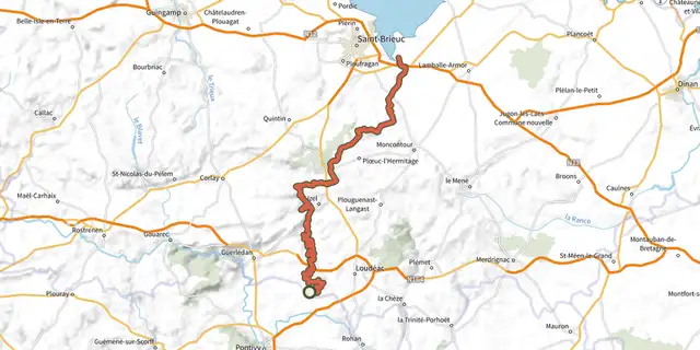
EV4 - La Vélomaritime® - section 4/5

Key facts
- Distance
- 43.8 km
- Ascent
- +523 m
- Descent
- −451 m
- Estimated time
- 2 hr 25
- road cycling
- Difficulty
- Difficult
- official rating
- Route
- Out and back
- same way back
Profile and gradient
- under 10%
- 10 to 20%
- over 20%
Gradient along the route: 43.8 km under 10%. Elevation from 0 m to 127 m over 43.8 km.
Difficulty
Official rating: difficult, by Département des Côtes d'Armor.
Getting there
Start: Pordic, Pordic (22).
Sources
- Track: Département des Côtes d'Armor, PDIPR, Licence Ouverte 2.0, Licence Ouverte 2.0 (Etalab) (rando.cotesdarmor.fr/velo/ev4---la-velomaritime---section-45/). Time estimated by GPX Path with the Mac app rule, breaks not included.
- Official elevation gain: 523 m, Département des Côtes d'Armor
Nearby tracks

 Plan IGN © IGN 2026EV4 - La Vélomaritime® - section 3/5Brittany, Lanloup (22) · Point to point
 Plan IGN © IGN 2026EV4 - La Vélomaritime® - section 5/5Brittany, Pléneuf-Val-André (22) · Out and backOfficial rating by Département des Côtes d'Armor
 Plan IGN © IGN 2026 · track © OpenStreetMapBoucle Matignon - Saint-Pôtan - RucaBrittany, Matignon (22) · Loop
 Plan IGN © IGN 2026EV4 - La Vélomaritime® - section 2/5Brittany, Penvénan (22) · Out and backOfficial rating by Département des Côtes d'Armor
 Plan IGN © IGN 2026V408 Saint-Brieuc LorientBrittany, Saint-Gérand-Croixanvec (56) · Point to point
 Plan IGN © IGN 2026V403 - Sarzeau - Saint-Méen-le-Grand - Saint-MaloBrittany, Pleurtuit (35) · Point to point