
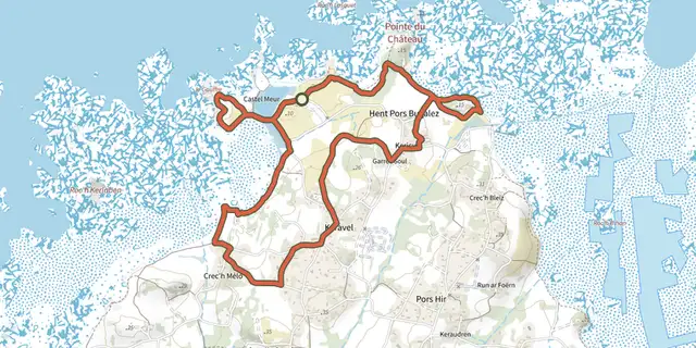
Circuit de Brestan

Fiche technique
- Distance
- 8,8 km
- Montée
- +98 m
- Descente
- −76 m
- Durée estimée
- 2 h 05
- randonnée
- Difficulté
- Facile
- cotation officielle
- Parcours
- Boucle
- retour au départ
Profil et pente
- moins de 10 %
- 10 à 20 %
- plus de 20 %
Pente sur le parcours : 8,8 km à moins de 10 %. Altitude de 6 m à 50 m sur 8,8 km.
Difficulté
Cotation officielle : facile, selon Département des Côtes d'Armor.
Accès
Départ : Pleubian, Pleubian (22).
Sources
- Trace : Département des Côtes d'Armor, PDIPR, Licence Ouverte 2.0, Licence Ouverte 2.0 (Etalab) (rando.cotesdarmor.fr/pedestre/circuit-de-brestan/). Durée estimée par GPX Path avec la règle de l'app Mac, hors pauses.
- Dénivelé positif officiel : 98 m, Département des Côtes d'Armor
Traces voisines

 Plan IGN © IGN 2026Circuit de Brestan à Port BéniBretagne, Pleubian (22) · Boucle
 Plan IGN © IGN 2026Circuit des pharesBretagne, Pleubian (22) · Boucle
 Plan IGN © IGN 2026Boucle du JaudyBretagne, Kerbors (22) · Boucle
 Plan IGN © IGN 2026Circuit de l'enferBretagne, Plougrescant (22) · Boucle
 Plan IGN © IGN 2026Balade au pays des Tors - Sentier de découverteBretagne, Plougrescant (22) · BoucleCotation officielle selon Département des Côtes d'Armor
 Plan IGN © IGN 2026De Traou-Meur à Saint-NicolasBretagne, Trédarzec (22) · Boucle